
Page 175 - 360.revista de Alta Velocidad - Nº 6
P. 175
Which way to the city centre? Pedestrian itineraries between High Speed Rail stations and historic
centres. Assessing urban quality and tourist behaviour through GPS tracks in Toledo.
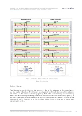
Figure 7: Longitudinal characteristics of the southern itinerary.
Source: Own elaboration
Northern Itinerary
This itinerary is more legible than the south one, due to the relevance of the arterial street
and the traffic indications. The itinerary is not pedestrian friendly because of the adjacent
fast traffic and the narrow footpaths (Figure 8). Both sides have continuity and accessibility
difficulties after crossing the bridge, but these are even worst in the north one (Figure 8). In
addition, in the south side the views to the river and the historic city are not disturbed by the
presence of traffic. However, as in the Alcántara Bridge itinerary, there are no tourist signs
indicating this option.
International Congress on High-speed Rail: Technologies and Long Term Impacts - Ciudad Real (Spain) - 25th anniversary Madrid-Sevilla corridor 173