
Page 172 - 360.revista de Alta Velocidad - Nº 6
P. 172
Coronado, José María. Moyano, Amparo. Romero de Ávila, Vicente.
Rodríguez Lázaro, Francisco Javier. Ruiz Fernández, Rita.
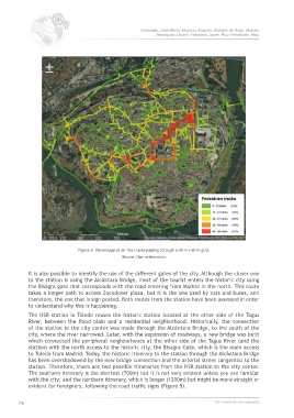
Figure 3. Percentage of all the tracks passing through a 40 m x 40 m grid.
Source: Own elaboration.
It is also possible to identify the use of the different gates of the city. Although the closer one
to the station is using the Alcántara Bridge, most of the tourist enters the historic city using
the Bisagra gate that corresponds with the road entering from Madrid in the north. This route
takes a longer path to access Zocodover plaza, but it is the one used by cars and buses, and
therefore, the one that is sign posted. Both routes from the station have been assessed in order
to understand why this is happening.
The HSR station in Toledo reuses the historic station located at the other side of the Tagus
River, between the flood plain and a residential neighborhood. Historically, the connection
of the station to the city center was made through the Alcántara Bridge, to the south of the
city, where the river narrowed. Later, with the expansion of roadways, a new bridge was built
which connected the peripheral neighborhoods at the other side of the Tagus River (and the
station) with the north access to the historic city, the Bisagra Gate, which is the main access
to Toledo from Madrid. Today, the historic itinerary to the station through the Alcántara Bridge
has been overshadowed by the new bridge connection and the arterial street tangential to the
station. Therefore, there are two possible itineraries from the HSR station to the city center.
The southern itinerary is the shortest (700m) but it is not very evident unless you are familiar
with the city; and the northern itinerary, which is longer (1200m) but might be more straight or
evident for foreigners, following the road traffic signs (Figure 5).
170 360.revista de alta velocidad