
Page 173 - 360.revista de Alta Velocidad - Nº 6
P. 173
Which way to the city centre? Pedestrian itineraries between High Speed Rail stations and historic
centres. Assessing urban quality and tourist behaviour through GPS tracks in Toledo.
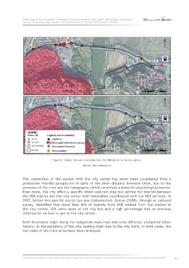
Figure 5: Toledo: the two itineraries from the HSR station to the city centre.
Source: Own elaboration
The connection of the station with the city center has never been considered from a
pedestrian friendly perspective in spite of the short distance between them, due to the
presence of the river and the topography, which constitute a powerful psychological barrier.
Even more, the city offers a specific direct and non-stop bus service for tourists between
the HSR station and the city center with timetables coordinated with the HSR services. In
2007, before this specific tourist bus was implemented, Guirao (2008), through an onboard
survey, identified that more than 40% of tourists from HSR walked from the station to
the city center, 20% were users of the city bus and a high percentage had no previous
information on how to get to the city center.
Both itineraries begin along the tangential main road and cross different unplanned urban
fabrics, at the periphery of the city, making their way to the city walls. In both cases, the
two sides of the itineraries have been analyzed.
International Congress on High-speed Rail: Technologies and Long Term Impacts - Ciudad Real (Spain) - 25th anniversary Madrid-Sevilla corridor 171