
Page 171 - 360.revista de Alta Velocidad - Nº 6
P. 171
Which way to the city centre? Pedestrian itineraries between High Speed Rail stations and historic
centres. Assessing urban quality and tourist behaviour through GPS tracks in Toledo.
the itinerary may not be really useful, as excellent resulting sections may cover up the poor
ones. Also, no aggregate measures for each section have been assigned, since this aggregation
would say nothing about how to address the deficiencies (Jaskiewicz, 2000).
4. Results
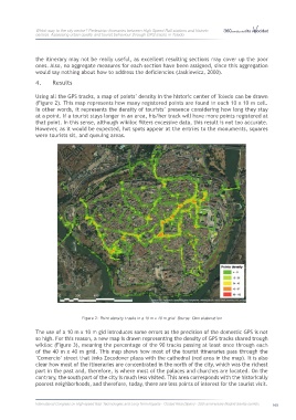
Using all the GPS tracks, a map of points’ density in the historic center of Toledo can be drawn
(Figure 2). This map represents how many registered points are found in each 10 x 10 m cell.
In other words, it represents the density of tourists’ presence considering how long they stay
at a point. If a tourist stays longer in an area, his/her track will have more points registered at
that point. In this sense, although wikiloc filters excessive data, this result is not too accurate.
However, as it would be expected, hot spots appear at the entries to the monuments, squares
were tourists sit, and queuing areas.
Figure 2: Point density tracks in a 10 m x 10 m grid. Source: Own elaboration
The use of a 10 m x 10 m gid introduces some errors as the precision of the domestic GPS is not
so high. For this reason, a new map is drawn representing the density of GPS tracks shared trough
wikiloc (Figure 3), meaning the percentage of the 90 tracks passing at least once through each
of the 40 m x 40 m grid. This map shows how most of the tourist itineraries pass through the
‘Comercio’ street that links Zocodover plaza with the cathedral (red area in the map). It is also
clear how most of the itineraries are concentrated in the north of the city, which was the richest
part in the past and, therefore, is where most of the palaces and churches are located. On the
contrary, the south part of the city is much less visited. This area corresponds with the historically
poorest neighborhoods, and therefore, today, there are less points of interest for the tourist visit.
International Congress on High-speed Rail: Technologies and Long Term Impacts - Ciudad Real (Spain) - 25th anniversary Madrid-Sevilla corridor 169