
Page 195 - 360.revista de Alta Velocidad - Nº 6
P. 195
Processes, urban impact and evaluation of the high-speed rail in the city of Zaragoza, Spain.
14. Urban planning in Portillo area, AC-19.
The process of urban planning was not easy for the society from the beginning. The City planning
department had their own ideas for the area and wanted to remain its criteria. The department
raised a verbal agreement with the Society; the society would define the planning for the
Delicias area and the City Council would define the Portillo area. Both entities would accept
the other´s design.
Among the whole area, the most strategically area was Portillo. Located in the centre of the
city was relevant to define correctly the urban design elements. The uses provided in this place
were mainly public facilities and a big park, called to be the central park of the city.
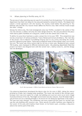
To define the area there had been a public competition in the year 1999. This competition was
won by a local team of various architects: Franco-Pemán and Cerouno Architects. The main idea
of the project was to dispose the buildings linearly next to city center, liberating the central
part for a generous green space. There was an elliptical tower in the southern area, as an iconic
element. The tower was ninety meters high for tertiary or hotel uses. Residential uses, around
700 housing, were displayed in different peripheral parts. City planning department liked the
project but there was disagreement with the winner team, mainly economic, and the design
was not developed.
Fig 19. Winning proposal in 1999 by Franco-Pemán and Cerouno. Source: Pablo de la Cal.
City planning department developed the Master plan for the area in 2003, taking the winner
proposal as a base, but changing some questions. The tower was moved to the northern part,
because there was more space for a high-rise building and could act more as an iconic image
from the entrance of the city. The height of the tower was also reduced, from 90 meters high to
only 20 floors and an a estimated height of 70 meters for not doing too significant in the skyline.
The uses were also changed. The residential uses were erased and the tower for tertiary uses
was the only building with lucrative uses. Three parcels for public facilities were disposed in
the border of the area with Anselmo Clavé Street, in the Eastern part, providing a big green
area in the central part of the area.
International Congress on High-speed Rail: Technologies and Long Term Impacts - Ciudad Real (Spain) - 25th anniversary Madrid-Sevilla corridor 193