Page 475 - 360.revista de Alta Velocidad - Nº 6
P. 475
Atlas-rail: geo-referenced database on high-speed


                   Atlas-Rail database, UIC Statistical  Yearbook and the data that companies, operators
                   or agencies wish to provide enable a very wide range of map contents as well as other
                   supporting elements to illustrate the geographical reality of high-speed networks in the
                   world, continents or even on a smaller scale.

                   All this depending on the data availability and the required level of detail to be depicted
                   in the document.

                   The following are some examples of this cartographic tipology. They are shown from small
                   to large scale.


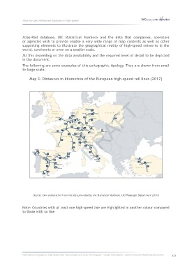
                        Map 3. Distances in kilometres of the European high-speed rail lines (2017)


                           Source: Own elaboration from the data provided by the Statistical Yearbook, UIC Passenger Department (2017)


                   Note: Countries with at least one high-speed line are highlighted in another colour compared
                   to those with no line


                   International Congress on High-speed Rail: Technologies and Long Term Impacts - Ciudad Real (Spain) - 25th anniversary Madrid-Sevilla corridor  473

