
Page 184 - 360.revista de Alta Velocidad - Nº 6
P. 184
Fernández-Ges, Andrés.
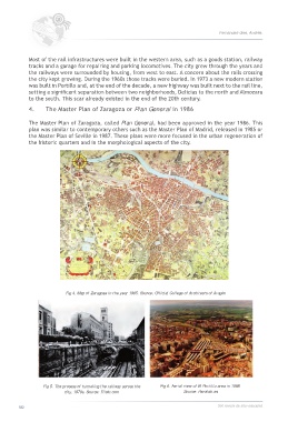
Most of the rail infrastructures were built in the western area, such as a goods station, railway
tracks and a garage for repairing and parking locomotives. The city grew through the years and
the railways were surrounded by housing, from west to east. A concern about the rails crossing
the city kept growing. During the 1960s those tracks were buried. In 1973 a new modern station
was built in Portillo and, at the end of the decade, a new highway was built next to the rail line,
setting a significant separation between two neighborhoods, Delicias to the north and Almozara
to the south. This scar already existed in the end of the 20th century.
4. The Master Plan of Zaragoza or Plan General in 1986
The Master Plan of Zaragoza, called Plan General, had been approved in the year 1986. This
plan was similar to contemporary others such as the Master Plan of Madrid, released in 1985 or
the Master Plan of Seville in 1987. These plans were more focused in the urban regeneration of
the historic quarters and in the morphological aspects of the city.
Fig 4. Map of Zaragoza in the year 1965. Source: Official College of Architects of Aragón
Fig 5. The process of tunneling the railway across the Fig 6. Aerial view of El Portillo area in 1998.
city, 1970s. Source: Flickr.com Source: Heraldo.es
182 360.revista de alta velocidad