Categories
Publications
Creating Railroad Risk Maps from incident knowledge base heatmaps
21/2/2012

Author/s: José Gómez Castaño
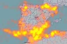
One of the most important tasks facing any Infrastructure Manager is to anticipate possible problems that may occur in them. To do this, the most effective is to have preventive procedures can anticipate possible situations. To achieve this goal, having a knowledge base is essential. You need to know what type of incidents have occurred and where. This article describes how to leverage the geospatial component of this knowledge base using the technique of representing incidents such as heat maps or “heatmaps”.
The heat maps are graphical representations shown in the areas of greatest activity of a certain variable. In this case there are areas with more incidents, according to various attributes. The result is the generation of risk maps.
This article shows how to develop some programs that respond to a procedure to generate heat maps from the basic event data.
Keywords: GIS, heatmap, kml, events, risk maps, python, openlayers, google maps.
Publication: Vía Libre Railway Research Nº 5
Download paper »


